Ukraine update: Mapping positions at the start of day 70
This post was originally published on this site
The action for the last few days of Russia’s invasion of Ukraine has been at the two extreme ends of the long “front”—near Kherson in the southwest and near Kharkiv in the northeast. That was mostly true again on Tuesday.
Kharkiv Area
Ukrainian forces entered the area of Staryi Saltiv on Sunday, and fighting in the town continues. Because the bridge over the broad Siverskyi Donets River at Staryi Saltive was blown up by Ukrainian forces early in the war, Ukraine can’t use that bridge now to extend their push to the east bank of the river. On the other hand, Russian forces can’t use that bridge to escape. So instead, Russian forces are moving north while Ukrainian forces clean up and take control of the area to the south of the town.
On Tuesday, that included Ukrainian forces moving into the town of Molodova. Securing that location helps to straighten out what had been a rather crooked path for forces moving between Kharkiv and Staryi Saltiv, and seems a pretty good indicator that there remain little or no Russian forces on the west bank of the river south of the former bridge. However, there remain two settlements on the road running directly west from Staryi Saltiv that on Monday were still in Russian control. Based on Telegram messages (and generous use of Google Translate) there are reports that Russian forces have left both of these locations. There are other reports that battles are going on for these locations. Pending any kind of official announcement, I’ve labeled them both as “in dispute.”
On the extreme northwest of the Russian-occupied territory, Ukrainian forces have reportedly moved closer to the town of Kozacha Lopan. However, there seems to have been no real movement along the roads running directly north out of Kharkiv, with no reports of Russian forces being pushed back (or of failed attempts).
Izyum area
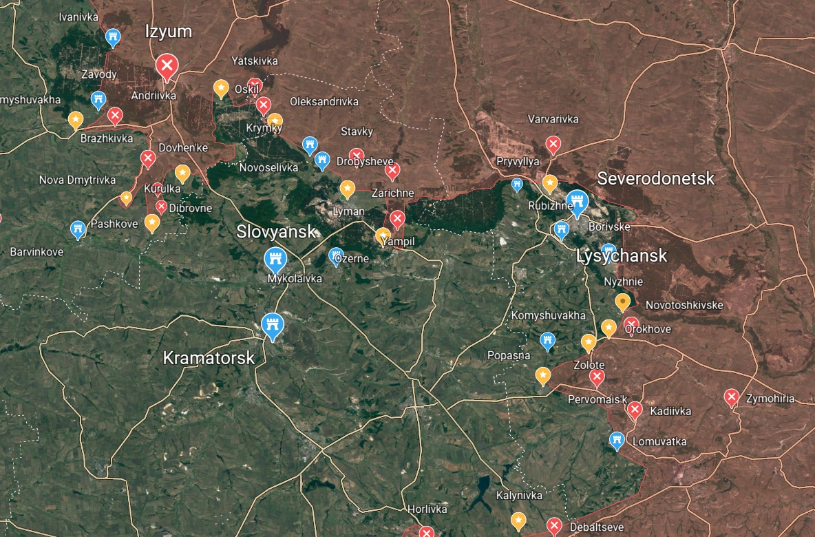
The central part of the line is where Russia has most of its force allocated, with roughly 68 Battalion Tactical Groups squeezed in from Izyum down to Donetsk. The biggest change on the map today is that it more accurately reflects the number of points that are actually in dispute, because—as it has almost since the start of the war—Russia seems to be making a large number of attempted breakthroughs by relatively small forces.
The only one of these to make anything like significant progress in the last two days is that small salient jutting down east of Slovyansk starting at the town of Zarichne. That push has secured Russian forces a series of small villages, and on Monday they seem to have consolidated control of Yampil. They’re now on to the next village in the line, but where they’re going from there is still in question.
Further south, Russia is still trying to capture Popasna. It still doesn’t have it. I swear, when I first wrote about this little town, I had no idea it was going to be the absolute focus of Russian efforts for three solid weeks.

Kherson Area
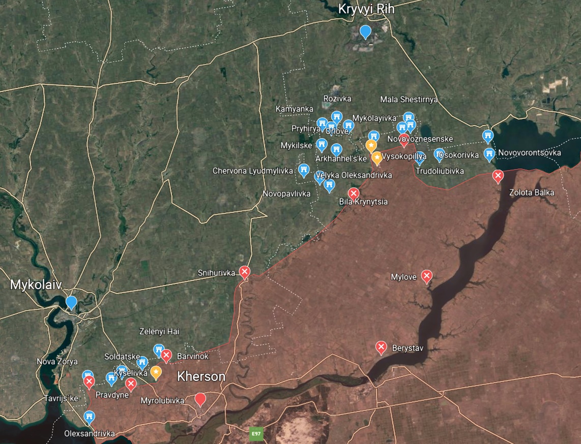
The only thing I know for sure about activity in the Kherson area over the last 48 hours is that I spent a lot of time reading Twitter and Telegram posts about every single city, town, and village I could find in an effort to understand who currently controls what and where Russia is going.
Honestly, the Russian push toward Kryvyi Rih seems as pointless as ever—more an exercise in trying to taunt Volodomyr Zelenskyy by threatening his hometown than a serious military effort. But there is definitely activity in the area, and several villages under dispute. It can be assumed that Russia occupies a large number of villages and towns on the west bank of the Dnipro in the middle of the highlighted area, but I came up dry on anything indicating the status of any but a handful of locations. That may be related to reports that Russia is now channeling communication in the Kherson area through the Russian internet.
Expect this map to have fewer villages shown next time. It seemed necessary today to tag more locations to get a good definition of the current situation.

That’s pretty much it from me, as far as the activities that I stumbled over the day. Let’s see what the other guys say.
- The capture of Molodova and continued push around Staryi Saltiv is also the big story here.
- Russia hit a number of cities with missiles on Tuesday, causing some fairly extensive damage to electrical facilities and train lines.
- Russian troops attempted to advance towards Slovyansk, but “the attack wasn’t successful.”
- Also noted is the withdrawal from Yampil towards Ozerne.
- No change around Kherson so … good, I didn’t miss anything.
- Russian forces have launched another attack on the Azovstal steel plant in Mariupol, but no word yet on the outcome.
- Ukrainian forces secured Molodova
- Staryi Saltiv is still shown under Russian control.
- Russian attacks in Rubizhne, Popasna, and Lyman, but none of those three were taken.
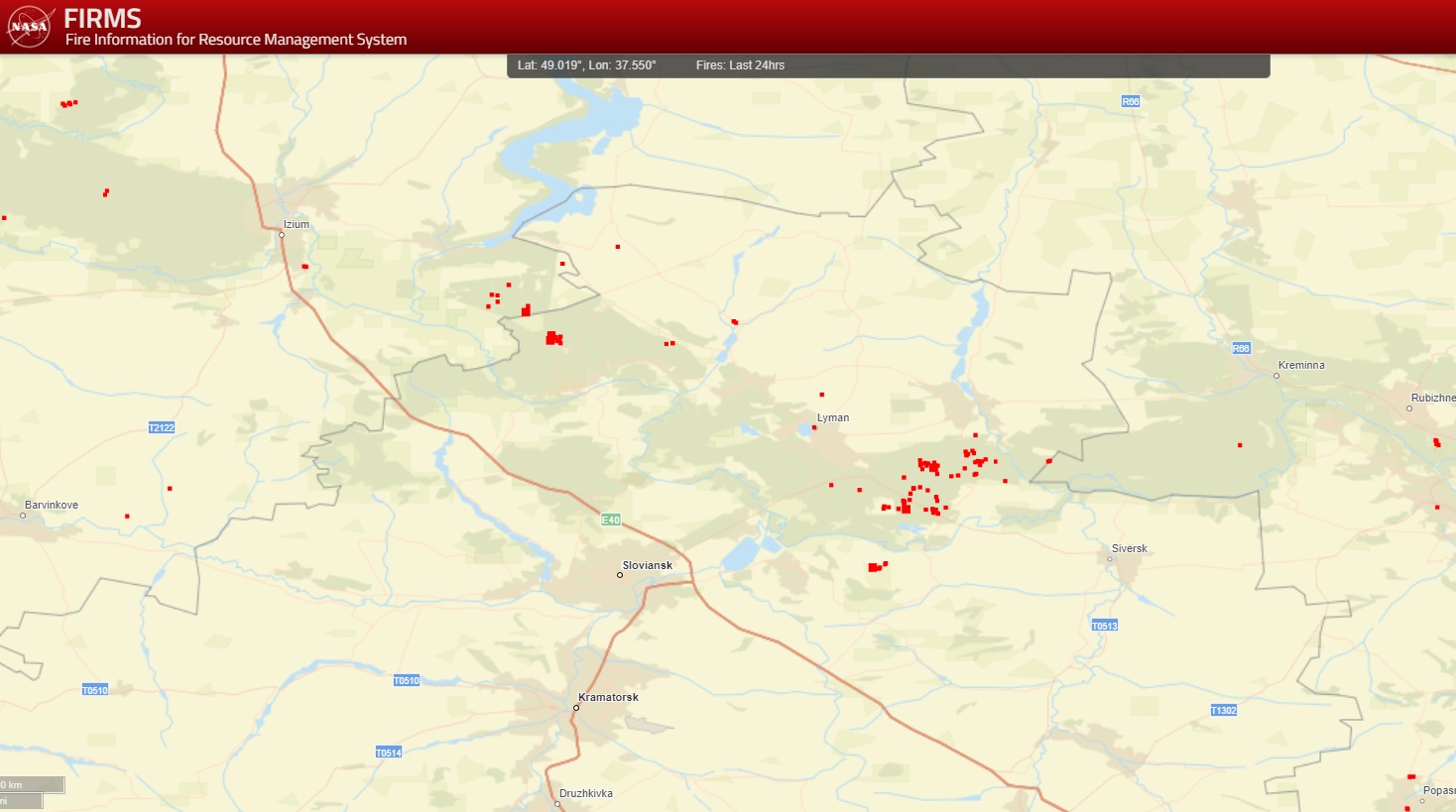
NASA FIRMS Firemap
The only areas where there seem to be significant numbers of fires on the NASA FIRMS Firemap over the last 24 hours are in the area SW of Lyman—that’s the area of Yampil and the village of Ozerne that’s currently in dispute. A good deal of this fire seems to be the result of Ukrainian artillery firing into Russian positions. The patch of fires to the northwest of Slovyansk is in the little “valley” of Ukrainian control south of Oskil. That suggests this is Russian artillery firing in.

Wednesday, May 4, 2022 · 2:29:39 PM +00:00
·
Mark Sumner
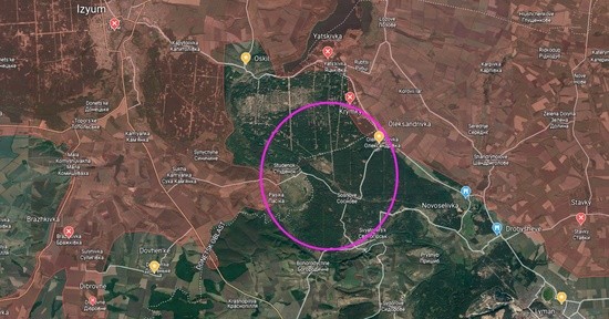
One of the things that looks concerning this morning is the sheer amount of fire being poured into this small area.

Both Ukraine satellite flashes (@ukr_satflash) and the NASA FIRMS fire map have been tracking what looks to be heavy pounding of this area for the last two days. Though there’s been no official indication that Russian positions have advanced, the fire has move from Oleksandrivka on the east (shown here as that “in dispute” yellow marker) to the tiny crossroads village at Sosnove, just SE of the center of that circle.
This makes it seem very likely that Russia will attempt to cut across this area along the road between Oleksandrivka and Studenok on the west. What could hold this up? The bridge west of Studenok is reportedly out.
The Siverskyi Donets River looks to be about 250 wide at this point, and swiftly flowing after spring rains. It would be hard to span with a pontoon bridge. However, Russian engineering teams may be working to fix this bridge or create some other crossing. It’s hard to imagine that Sosnove and the surrounding area would be getting the kind of pounding it’s now receiving unless Russia intended to make some move in this area.
