Ukraine update: Two small towns at the center of the world
This post was originally published on this site
This morning, kos wrote about the defensive line established in 2014 between the Russian occupied areas of Ukraine and the areas under control of the Ukrainian military. Russia has been trying, in little ineffective fits and starts, to get around this line and surround the Ukrainian forces that defend it. The whole massive buildup going on at Izyum is part of Russia’s effort to finally, finally pull this thorn from it’s efforts to secure all of the Donbass. If, that is, Russia can manage to move more than a single unit at a time.
This is that same story … on a smaller scale.
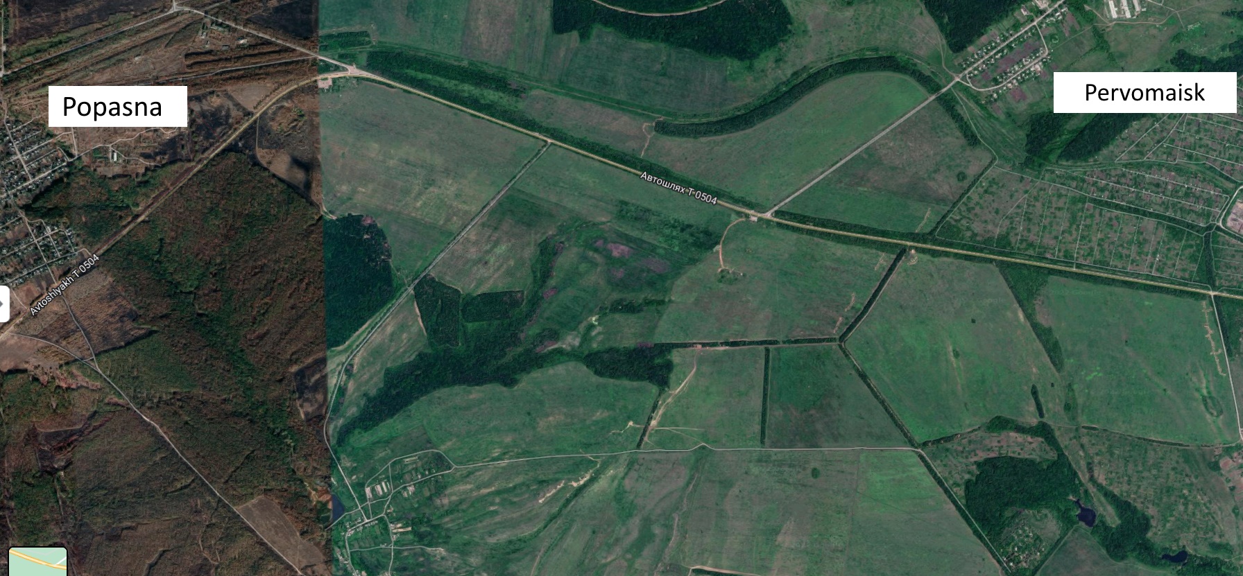
This is an image of two small towns in eastern Ukraine. On the west side is the town of Popasna, population 19,000 (in 2010). On the right is Pervomaisk, population 36,000. Don’t be fooled by the apparent line between the two; that’s just an artifact of the different times when satellites used by Google took images of the area. The left side was captured in the late fall of 2019, the right side in spring of the same year.
From this altitude, nothing appears to be all that unusual about these two mid-sized towns. It’s easy to pick out streets and schools, stores and churches. In the narrow space between the two, there’s nothing that would be called a serious hill and not so much as a single continuously flowing stream, much less a river. It’s just fields. Flat farm fields with a few irrigation ditches. They might as well be in the middle of Illinois. Or Indiana. Or Iowa. One of those ‘I’ states.
But distance is definitely deceiving. There’s nothing ordinary about these two little towns. And while they’ve gotten little attention so far, that two miles between them might be the center of the world.
In April of 2014, pro-Russian separatists driving Russian tanks, firing Russian weapons, and accompanied by Russian forces, captured a number of towns in Luhansk. That included both Popasna and Pervomaisk. In July, Ukrainian forces drove the separatists from the area and in August Ukraine proclaimed both towns “secured.” Only Pervomaisk didn’t seem to be quite so secure. Separatists were still present in the area, and both sides ended up with artillery planted in the middle of civilian neighborhoods, exchanging fire in a very ugly battle. By January of 2015, half the town had either fled, or died. But eventually the town was left in the control of the pro-Russian forces of the Luhansk People’s Army. It’s been that way ever since.
Meanwhile in Popasna, Ukrainian forces retook the town in June, 2014. Then pro-Russian forces took it in July. Then the pro-Ukrainian Donbas Battalion took it a couple of days later. That’s where the town has remained ever since — on the bleeding outskirts of Ukrainian control, held by a mixture of regular Ukrainian military and local territorial defense. As in Pervomaisk, a lot of the population departed. That’s probably good, because in all of what was previously a town of 20,000, there are now two functioning stores. There’s a grocery store on the map, but it’s operated by an aid agency that distributes food to local residents. Electricity is spotty, and good luck getting health care.
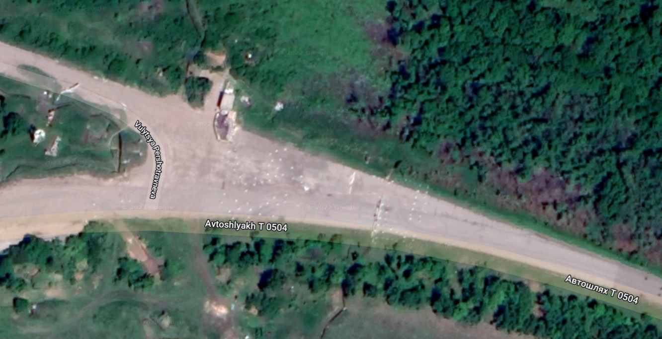
Now, here’s a closer look at that apparently nondescript spot of farmland between the two towns.

Can you see it? Granted, what’s special here isn’t all that visible at this scale. One thing that might be surprising is that the road that seems so clearly visible on the north edge of this image isn’t really something vehicles can travel along. Not unless they are adept at getting around:
1) Wrecks. Those light spots near the intersection southwest of the Pervomaisk nametag are mostly the remains of vehicles that were blown apart along this course.
2) Potholes. Actually, potholes from hell. There are shell craters in this road, especially west of that intersection, that could swallow a car whole.
3) Mines. That little intersection just east of the Popasna sign marks the west edge of a mine field.
Here’s a closer look at that last one.

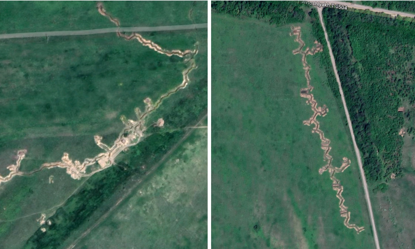
But there’s something in the fields between Popasna and Pervomaisk that’s even more special than the mine-laden road. It’s those things that look like barely visible squiggly lines running roughly north -south through the second image above. Seen from close up, they’re definitely not irrigation ditches.

This time the line in the middle of the image really does mean something. It’s where almost exactly one mile of space has been left out. That’s what separates the trenches on the left, dug into some low hills outside of Popasna, from the trenches on the right, which are along a slight rise on the shoulder of a road near Pervomaisk.
These are not a simple ditches. Like the trenches dug across France in World War I, these are elaborate constructions, braced by wood, intentionally non-linear to make them harder to target, and flanked by mounds of earth. Both sets of trenches have locations meant to allow armored vehicles to tuck inside for shelter. Both have gun emplacements for mortars and artillery, either connected to the trenches themselves or in the woods nearby. The Popasna line includes a number of small shelters, likely to allow soldiers to get some respite from the weather, or to act as local command posts.
With all that in mind, here is a news item from Saturday morning.
Rubizhne is about 20 miles to the north. The situation there is more difficult because the Sievierskyi-Donetsk River runs through the area. With the rain that’s been falling across eastern Ukraine in the last two weeks, that again makes bridges a premium item when it comes to moving forces. Both Sievierodonetsk and Rubizhne guard access to bridges.
When word comes that Russian forces have tried to break through at a location like Popasna, what it means—especially right now, in mud season—is that they have attempted to drive a column of vehicles up that wreck-strewn, potholed, heavily mined highway with entrenched forces firing into them from both north and south. It should be no surprise that such attacks are getting regularly repulsed. When kos talks about all the pressure along the defensive line, and Russia’s repeated failures to penetrate the existing defenses, it’s places like Popasna and Pervomaisk he’s talking about.
If you’ve ever been to a famous battlefield, one where the numbers of dead and wounded were simply hideous, odds are it was some place like this. Open fields, with little to no cover, where anyone who wants to be the aggressor has to cross a mile of grass in clear view of dug in defenders.
For eight years, pro-Russian forces have been trying to push west into Popasna. They’ve failed. Likewise, for the same eight years Ukrainian forces have wanted to take back Pervomaisk. They’ve also failed.
Keep in mind that all the images above date from 2019. You can bet that at this point both the trenches and the minefields and the lines of wrecks are all much larger.
Given a few months, when things dry, those attacks can spread out into those flat fields, with tanks and other armor racing straight toward the forces in trenches; forces that at this point you can bet are all but saturated with anti-tank missiles. What happens then? See the dates when Popasna rapidly changed hands in 2014? June. July. Those are the months when forces here won’t be confined to moving along that shot to hell road.
What happens then is anyone’s guess. But if Russia wants to take it, they’re going to have to coordinate more than a single small group of forces.
Saturday, Apr 16, 2022 · 4:35:27 PM +00:00
·
Mark Sumner
The rain won’t go on forever. Neither will the current stand off.
Saturday, Apr 16, 2022 · 4:37:57 PM +00:00
·
Mark Sumner
Here’s a genuine sign of recovery that many of us can feel deeply.
Yes. Yes, I have been very happy after visiting bookshop.
Saturday, Apr 16, 2022 · 4:40:51 PM +00:00
·
Mark Sumner
You may have already seen some version of this. Watch it again.
